|
|
|
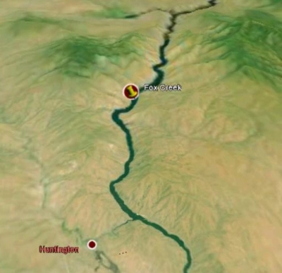
A composite topographic and satellite map of 50-mile-long Brownlee Reservoir, looking north from Huntinton toward Fox Creek, Lookout Mountain, and Richland. We're about half way along Snake River Road which winds its way between Huntington and Richland. The Richland bay which enters from the left, is where the Powder River enters the Snake River. The reservoir and dam are named after a Mr. Brown and a Mr. Lee, who operated a ferry across the Snake River in the mid-1800's. The half-mile-wide river/reservoir forms the boundary between Oregon and Idaho and also the boundary between Pacific and Mountain time. We're glad that the river/reservoir bends to the right at Fox Creek. That causes most of the power boats to pass near the opposite shore. This rugged area is known as the Snake River Brakes. The Snake River flows north from here to Hells Canyon, which is the deepest gorge in North America. Huntington is located on the Burnt River, which turns left and flows into the Snake River about 2 miles northeast of Huntington. The Oregon Trail leaves Farewell Bend just south of Huntington and heads up the Burnt River Canyon, now the site of I-84.
|
|
|
|
|